Registration: Both Grand Teton walks are available at the AVA Online Start Box (ava.org, then search for Yellowstone event).
We recommend you check the national park service page before your trip to make sure the trails you plan to do (and the road to them) are open. See link below.
Elevation: These hikes start at an elevation of 6,000 feet or more above sea level. It is recommended that you first acclimatize to the altitude before attempting a moderately strenuous hike. If planning to do both hikes, Fairy Falls has a lower elevation and is an easier hike, making it a good “acclimatization” walk.
Miscellaneous: Yellowstone National Park has an entrance fee. Golden Age or Golden Eagle passes can be used. Summer temperatures in Wyoming may be 90 degrees F or more. Carry water on the trail plus sunscreen and a hat! Check with visitor center for trail conditions before heading out. Do not attempt these trails if snow or heavy rain are in the forecast. Not suitable for strollers or wheelchairs. Pets may accompany you in the front country areas of the park. This includes any areas within 100 feet of roads, parking areas, and campgrounds. Pets must be kept under physical control at all times - caged, crated, or on a leash not to exceed six feet in length. See more information regarding pets here: http://www.nps.gov/yell/planyourvisit/pets.htm
Links:
National Park Page Directions to Yellowstone
Directions to start point : Yellowstone National Park is located in the western United States. It spans 3,472 square miles (8,987 square km). Ninety-six percent of the park is located in the state of Wyoming, another three percent is in Montana, and one percent is in Idaho. See the link above for detailed directions.
Questions? Contact: Marcia Stein: Phone 206-713-1564 or email
|
Fairy Falls & Imperial Geyser
Distance: 11K 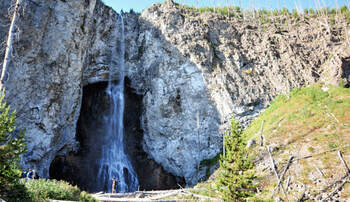
Trail (1C): This is a family-friendly walk on almost totally level terrain. The sights, however, are unlike any others. From the trailhead, walk 1.6 miles (2.6 km) through a young lodgepole pine forest to the falls. You can continue 0.6 miles (0.97 km) to Spray and Imperial geysers, which adds 1.2 miles (1.9 km) to the hike. On our exploratory hike, buffalo were on the trail with us, so don’t let the easy hike lull you into lack of awareness of your surroundings. This is also a Bear Management Area. For your safety, obey posted signs. To avoid crowds, leave the parking lot early.
|
Chittendon Road to Mt. Washburn
Distance: 10K , 1,400’ elevation gain 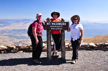
Trail (3C): This is one of the park’s most popular hikes, so you might want to start early. The trail starts high from a small parking area on the highway and goes up to 10,243 ft. It follows an old wagon road all the way to the fire lookout at the top of the mountain. In addition to an outhouse, a pay phone (that only accepts credit cards), guest logbook, interpretive geology displays, and a powerful telescope in the sheltered ground-level observation room, the lookout offers incredible panoramas of most of the park from upstairs on the outdoor viewing platform. Yes, it’s rated 4+, but give it a try. It's a wide trail/road with a gentle grade. You'll be happy you did! For more information, see the NPS page here.
|
